The National Building Code of Canada requires a comprehensive geotechnical investigation for any major structure, and in Markham the variable glacial geology makes standard borehole data alone insufficient. The Oak Ridges Moraine deposits that underlie much of the city create layered sequences of sand, silt, and clay till where seismic velocity contrasts can be subtle but structurally significant. We run refraction and reflection tomography to image these transitions continuously across a site, bridging the gaps between point-source data from SPT drilling and lab testing. A single survey line can map bedrock topography under 30 meters of overburden without a single excavation, giving the structural engineer a calibrated shear-wave velocity model to feed directly into site class determination per NBCC Table 4.1.8.4.A. The result is a defensible foundation design that anticipates differential settlement before the first bucket of soil is moved.
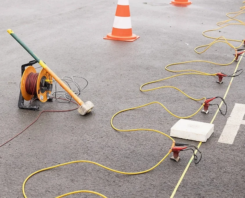
Seismic tomography turns a handful of borehole logs into a continuous cross-section, revealing what lies between the data points that traditional drilling alone cannot see.
Local ground factors
Markham's accelerated urbanization since the 1990s has pushed development onto lands once considered marginal: former floodplain edges along the Rouge and Don River tributaries, kettle-lake depressions filled with organic mud, and areas where the glacial till is discontinuously underlain by weathered shale of the Georgian Bay Formation. A foundation design based solely on widely spaced boreholes can miss a 3-meter drop in bedrock over a 15-meter lateral distance, creating a differential settlement problem that manifests as structural cracking within the first two years of occupancy. Seismic tomography addresses this directly by imaging the overburden-bedrock interface as a continuous reflector. On one warehouse project near Woodbine Avenue, our reflection profile identified a paleo-channel completely invisible to the initial five-borehole grid; the structural engineer adjusted footing depths in that zone, avoiding a costly post-construction underpinning scenario. The risk is not theoretical in this municipality, it is mapped in the drift-thickness data published by the Ontario Geological Survey.
Frequently asked questions
How much does a seismic refraction or reflection survey cost for a typical Markham site?
Budget figures for a seismic tomography survey in Markham generally fall between CA$4,080 and CA$7,420, depending on the number of survey lines, total lineal meters, source type, and whether both refraction and reflection are required. A small residential lot with one refraction line is at the lower end; a multi-line commercial site requiring reflection processing and S-wave analysis trends toward the upper range. We provide a fixed-price scope after reviewing the site plan and drilling logs.
Can seismic tomography completely replace boreholes on a Markham project?
No, and we never recommend it. Seismic tomography provides continuous subsurface imaging between boreholes, but it requires at least one or two calibration points (borehole logs or CPT soundings) to tie seismic velocity to actual lithology. The most solid site characterization strategy combines targeted drilling with seismic profiles, giving you both the material properties from samples and the lateral continuity from tomography.
How does a refraction survey help with NBCC site classification in York Region?
NBCC Table 4.1.8.4.A defines site classes based on the average shear-wave velocity in the upper 30 meters (Vs30) and other criteria. Our refraction survey measures P-wave velocity directly, and we can derive S-wave velocity either through MASW analysis on the same geophone spread or by using established Poisson ratio correlations for the glacial sediments typical of Markham. The resulting Vs30 value places your site into Class C, D, or E, which directly influences the seismic design forces used by the structural engineer.
How long does a seismic survey take on a typical commercial lot in Markham?
Field acquisition for a single refraction line of 69 to 92 meters takes roughly half a day with a two-person crew, including setup and breakdown. A multi-line survey or one requiring reflection shooting may extend to a full day on site. Data processing and interpretation add 3 to 5 business days, after which you receive the tomographic cross-sections and a report with velocity-to-material correlations tied to your existing borehole data.